 Even if the cellular system is down and you are unable to make phone calls, your iPhone or Android smartphone can still be a useful tool–but you need to understand its limitations, and how to prepare your phone for emergency use.
Keep in mind, even when voice calls don’t work due to overloaded circuits, you still may be able to send text messages. It’s not unusual for texting to work even when you can’t make or receive voice calls with your mobile phone.
Plus, there are Wi-Fi and Bluetooth apps for voice calls and text messages, and offline maps and other apps which can still be used after the cellular phone system has crashed. This article provides an overview of must-haves and optional apps for iPhones and Android smartphones. If you prepare your phone now, it will be ready for emergency use when you need it. Do it now. It’ll only take a few minutes.
To help avoid virus and other device-damaging malware, we recommend that you only download apps from trusted sites such as the Apple Apps Store (iPhone) or Google Play (Android).
Note: If your smartphone or tablet works during an emergency situation, and it has these apps installed and you know how to use them, it can be very useful. However, these do not take the place of a 2-way radio which is an essential tool for GO-Bags and emergency situations, generally.
Phone Apps – Voice-Over-Internet (VOIP) Using Wi-Fi
Wi-Fi capable smartphones do not need to depend on the cellular network to make telephone calls or for texting. Auxiliary communications apps, such as ‘WhatsApp’ and ‘Skype’ work through the Internet not the cellular phone system. So, if you download one of these ‘free’ apps into your smartphone (or computer), you may still be able to make voice calls to a landline, or to a mobile phone that is inside a working cellular network, as well as to a nearby phone or computer equipped with the same app—as long as you have a Wi-Fi signal and access to the Internet.
Set this up for yourself, and for family and friends, and make sure they know how to use these tools. When the cellular system goes down, many will panic, so practice with these apps so that everyone is ready to use them when the need arises.
Unfortunately, just because you have a Wi-Fi signal does not mean that the Internet connection is active. You need both Wi-Fi and the Internet to use WhatsApp, Skype, and other voice-over-Internet (VOIP) apps. WhatsApp and Skype can also be used to send text messages via the Internet, but again, a Wi-Fi and Internet connection are necessary.
Ghost Rings. Keep in mind, too, that just because your mobile phone seems to be working, and you can hear it ringing the phone you are calling, this does not mean that the cellular system is functional. It only means that you are connected to a cellular tower. Unfortunately, that tower may no longer be connected to the rest of the system. If this is the case, the ringing you hear is a ghost ring; the other phone is not receiving the call.
Governments Disable Mobile Phone Networks. During an emergency situation or widespread disaster, the federal government sometimes shuts-out subscribers to the cellular system. Sometimes they commandeer the mobile phone system for their own emergency use. This can happen when they need to augment overloaded police and fire radio networks. In these situations, ordinary users are locked-out so that First Responders such as police, fire, and emergency workers, can use the mobile phone system to communicate. Another reason that the government sometimes shuts down the mobile phone system is to hamper communication between terrorists, or others, that the federal government doesn’t want to communicate.
Or, the system can go down as a result of a power outage, earthquake or weather event which damages cell towers, if the system becomes infected with a computer virus, or a dozen other reasons. With these realities in mind, we need to understand that we can’t depend on telephones for communication during emergency situations. If they work, great. If they don’t work, we need backup methods, like 2-way radios, for communicating with family and friends.
If the Internet and Wi-Fi are working there are other smartphone-based communication options. If the Internet isn’t working there are fewer smartphone communication options, but there are a few, such as FireChat (described below) or connecting an add-on device to your smartphone such as goTenna. Plus, your phone can be a storehouse of other useful offline information–if you have previously downloaded the apps you need.
Essential Phone Apps
In addition to Internet-based voice and text communication tools such as WhatsApp, there are many “free” and low-cost apps which can be a godsend if you have them loaded onto your phone in advance. Some can be used offline even without cellular or Wi-Fi connections, others have limited use when offline, while still others require Wi-Fi or an Internet connection to use.
These apps can also be downloaded onto smartphones, as well as most tablets and laptop computers and many electronic book devices such as new models of Kindle, but the automatic route-creating feature may not work. Still, even without the automatic routing features provided by your phone’s built-in GPS, the larger screens of these other devices can be a boost to navigation.
![]() Zello PTT Walkie Talkie rates mention as an essential app for emergency situations because it turns your device into a walkie-talkie. It is available for both iPhone and Android smartphone platforms, as well as tablets and computers. With it, you can join a public “CrowdSource Rescue” group to seek help, or you can use it to find people in your area who are in desperate need of emergency assistance. Moderated emergency channels are created on Zello to coordinate aid during every major crisis.
Zello PTT Walkie Talkie rates mention as an essential app for emergency situations because it turns your device into a walkie-talkie. It is available for both iPhone and Android smartphone platforms, as well as tablets and computers. With it, you can join a public “CrowdSource Rescue” group to seek help, or you can use it to find people in your area who are in desperate need of emergency assistance. Moderated emergency channels are created on Zello to coordinate aid during every major crisis.
And, with Zello you can also create your own group consisting of family or friends, and you can freely use it for fun times as well as emergency situations. These individuals can be reached when they are across town, traveling, or anywhere in the world, as long as they have the app and a wifi-Internet connection.
The less popular “pay” version, “ZelloWork,” includes additional features. It is used by companies and larger volunteer organizations such as the Cajun Navy. However, the “free” version is adequate for most people. It has 120 million users.
The downside is that Zello does require access to either your cellular phone’s data network or a wifi + Internet connection. It will not work without one or the other. Note: Zello does not take the place of having a 2-way radio! But if you have cellular service or an Internet connection, it can be a very useful communication tool.
For example, during hurricane Florence, this app was used by civilians to coordinate their own rescue efforts independent of government agencies, as well as to reach local police, fire, and emergency rescue and medical services. It would only be a guess as to how many lives were saved by Zello users, but it was significant. Unfortunately, though Zello is easy to use, it is not intuitive to set up. So, you might want to watch a few YouTube videos to get started.
Map Apps
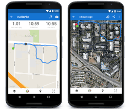
Download maps for offline use. Your smartphone and other portable electronic devices that you routinely carry should have maps installed so that you can use them even when the cellular phone system and Internet aren’t working. Google Maps has a feature which lets you download maps and store them in your device’s memory. These maps can even be downloaded onto a portable USB drive.
You don’t need a cellular or Internet connection to use these map apps if you have downloaded the version designed for offline use. If the GPS in your phone is still working, it can use these offline maps even when the cellular network and the Internet are down. And, even if your phone’s GPS is not working, you can still view the maps, but you’ll need to scroll through them manually. The ‘routing’ functions will not work, but the maps can still be used.
 US Topo Maps Pro and Canada Topo Maps Pro Download topographic maps from your area and any region where you might travel. Apps such as this are stored on your smartphone, offline, so they are available even when you do not have cellular coverage or Wi-Fi or Internet access. Topo Maps Pro is full-featured and can make an off-road or roadway trek in your car or on foot faster, and much safer because you can choose your route and be aware of terrain details. This app shows unpaved roads, footpaths, land features such as mountains, hills, valleys, crevices’, lakes, rivers, streams, and even elevations.
“Google Earth” by Google. Requires Wi-Fi and Internet connections. User selectable 2D or 3D satellite images of any location on earth. The app will automatically find and display the location where the smartphone is located. These are not real-time images. The app displays detailed aerial photos which are drawn from Google’s library which includes the most recent satellite photos they have available in their system.
 Compass and Location Apps
“Smart Compass” by Smart Tools Company, is available for both iPhone and Android smartphones. But whichever compass app you select, make sure it works offline, without a cell phone or GPS signal. Maps are essential, but you need to also know your direction of travel. A smartphone compass app is worthwhile even if you also have a mechanical compass.
“Military Navigation” by Wei Min. This app is designed for advanced navigation and allows the user to utilize compass degrees or mils, shows longitude and latitude, UTM zones, map grids, and other useful land navigation tools useful for those who have a military background.
“My Geo Position” provides the exact longitude and latitude of the smartphone and the closest street address. This can be used to find your location on an offline map or to communicate your position to friends, rescuers, or air-medical helicopters.
 Weather Apps
There are hundreds of weather apps to choose from, but among the most popular for weather-related emergencies are “Weather Underground” and “The Weather Channel.” It is to your advantage to have at least two weather apps installed on your device. Choose apps with complementary features, such as Weather Underground which includes crowd reporting, and The Weather Channel which includes projected-path radar.
Optional but Useful Apps
“FireChat” by Open Garden. Made famous when it was used by dissidents in China when their government had turned off the cellular phone system in an attempt to stop communication, FireChat not only doesn’t require the cellular system, it doesn’t even require the Internet. What it does require is other users in the area, as the user’s message is automatically relayed from one smartphone to another.
“Family Locator” by Life360. Using the GPS built into your smartphone and the phones of other family members or friends you add to your group, this app displays the location of each phone on a map, in real-time. If they are moving in a vehicle, you will not only see their location but also their direction of travel. If someone in your group becomes lost or unresponsive, this app can be used to find them. Group members must agree to this tracking, and they have the option to turn it off at any time.
“Hazards – IFRC” by IFRC. Alerts gathered from different reporting agencies. Monitor conditions in 5 areas in addition to the location of your phone. Developed by the Global Disaster Preparedness Center and Red Cross.
“Emergency” by American Red Cross. This free app provides notifications of impending severe weather and other hazards. It can also be used to check the weather conditions in areas where family and friends are located.
“Offline Survival Manual” by ligi. This app contains basic instructions on how to find water, build a shelter, first aid, fire making, edible plants, etc.
“Emergency Scanner” by News Radio. Though major urban areas are transitioning to encrypted communication for their police, fire, and emergency services departments, this app allows the user to listen to non-restricted governmental communication systems if the phone has Wi-Fi and Internet access. This includes the NOAA weather channels which have replaced the old Civil Defense notification system.
“Altimeter” by Stephane Sandon. A no-frills app which detects and displays the altitude (elevation) of your smartphone.
“MultiClinometer” by Calmatics (Physics Solutions). Includes a 2D spirit level, 2D clinometer, and a roll and pitch inclinometer. Displays in both digital and analog formats, in degrees or 1/10 degrees.
“Cargo Decoder” by Strategies Software. Input the information from the diamond-shaped placard which is required to be posted on all hazardous cargo being transported by truck, train, or aircraft, and this app will tell you about the cargo, the hazard, and a summary of information from the Emergency Response Guidebook published by the U.S. Department of Transportation.
“WISER” by the National Library of Medicine. CHEMM-IST support-tool for medical teams and emergency response personnel, this app is designed for use in mass casualty incidents. It includes databases from the Department of Transportation on hazards, Centers for Disease Control descriptions of bioterrorism agents, and Department of Homeland Security identification details for the various types of weapons of mass destruction.
Battery-Saving Tips for Smartphones
If cellular towers are not working, switch your phone to “Airplane Mode” and “Energy Saving” mode. If you don’t, your mobile phone will continuously search for a cellular signal, an activity which will rapidly drain your battery. And, if you are not actively using a map app or some other app, turn the phone ‘off’ to further extend battery life.
 Backup-Power for Phones and Electronics
Backup-Battery Devices. Inexpensive external batteries such as the 20,000 mAh polymer Lithium-ion powered PowerAdd Pilot X7 can be used to recharge your smartphone 4-8X, and other electronics as well, but only weighs 14-oz. A USB power cord for your phone is required but not included. Similar devices such as the 25,000 mAh Kizzon Power Bank are more expensive, but also more rugged and have a built-in solar panel to help recharge the unit itself.
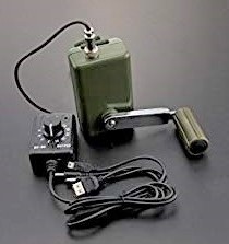 Crank Rechargers. Similar to the hand-crank chargers found on emergency radios such as the Kaito Voyager Pro, which can be used to recharge a smartphone if you have the proper connector, standalone crank chargers are also available. Models such as the ruggedized DF Robot Hand Crank Power Generator with voltage regulator can be used to recharge mobile phones, tablets, radios, flashlights, and rechargeable batteries in smart chargers. These are easy to use but require many minutes of cranking to fully charge an electronic device or battery. Yet, they are more reliable than the miniature solar chargers built into portable electronics.
Electrical Outlet Chargers and 12-Volt Car Chargers for Phones. It’s so basic that most people forget to include in their GO-Bag an ordinary wall-outlet charger, cigarette-lighter (auto) charger, and charger-cord for their smartphone. These are GO-Bag basics that are often neglected. If you have these everyday items and you have access to electrical power from the power grid or a vehicle, keep the battery topped-up in your smartphone.
 Special Purpose GPS Mapping Devices
Standalone GPS devices are becoming a tool of the past, but for emergency use (and backpacking), Garmin makes several noteworthy devices. The Garmin GPSMAP 64st uses a GLONASS receiver with quad helix antenna to improve sensitivity, and its built-in U.S. maps are in color and can overlay satellite imagery, a feature which makes both automatic and manual navigation more intuitive. The Garman GPSMAP with preloaded maps of Canada is also available. Importantly, this device uses disposable Alkaline AA-batteries, so a charger is not necessary.
 The Garmin Rino 755t is a similar unit, but it incorporates a GMRS 2-way radio into the same device. Though not nearly as powerful as an Amateur (ham) 2-way radio, if you equip other family members and friends with this unit, you can still communicate if you are in the general proximity of each other. Another noteworthy feature of the Rino is that it can be used to automatically send coordinates to others in your group, making it easier to find a lost family member or friend.
Most navigation apps such as Google Maps, and GPS devices such as Tom Tom, Magellan, and Garman Nüvi, are designed to find favorable routes on major roadways and freeways. This is of marginal value during an emergency situation since traditional routes may have become unsafe or impassable. The only viable electronic devices for use in an emergency situation are those that will work offline, without a GPS or Wi-Fi signal. If you install a topographic map app, rather than just street maps, this can be a big plus. But, even with expensive high-detail maps, don’t expect the routing feature to work. If governmental or commercial systems fail, you will only have an electronic map.
Reliability Concern. These electronic navigation tools, like all GPS equipped devices, won’t provide navigation if the GPS satellite system has failed, been switched off, or intentionally tweaked to deliver false readings to enemies who might use the system.
Bottom-line. Don’t count on electronics. Don’t consider them to be a primary tool during an emergency. If they work, great, but expect them to fail. This isn’t an extreme viewpoint or harsh, it’s the voice of experience.
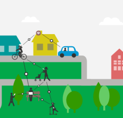
 Practice. Practice. Practice. An emergency situation is not the time to learn how to use a new app or electronic device. Don’t just turn it on to see if it works, take the time to use these tools in the field, as if you need to evacuate, or find an alternate route due to flooding or social unrest. Practice with family and friends. Practice needn’t be a laborious task. Make it fun.
Geocaching is a sport that can be undertaken individually, or with friends or family. It is designed to help you learn how to use the GPS on your phone or a standalone GPS device. Essentially a treasure hunt, geocaching is a game in which you search for the hidden treasure left behind by a geocaching club. Or, create your own “explorer” game to make practice fun. But regardless of how you practice, use these apps and devices now, so you are familiar with how to use them when an emergency arises.
In addition to practicing with these tools, select alternative routes between home, work, school, shopping areas, and other places frequently visited. Drive the routes and familiarize yourself with these unexplored surroundings now, when things are calm. Use your electronics to help identify routes now, while they are working, but be sure to jot down directions for later use, or mark these routes on paper maps and store them in your GO-Bag.
Rather than always depending on your phone’s GPS, use your offline tools routinely, to find your way to lunch meetings and appointments. Become familiar with these tools.
Mobile phone apps and electronic devices provide ease-of-use and other conveniences, and they should be used when available, but they should not be considered essential. What are essential is paper maps, an orienteering compass, 2-way radios, and a GO-Bag of water, food and emergency gear. You need to be able to get down the road to your home or safe-haven retreat location without electronics, and even without a vehicle. Don’t be dependent on modern technology for your safety.
Click on this link to download a PDF copy of this article: Smartphone_Apps_for_Emergencies-36READYdotCom

You must be logged in to post a comment.